• Home
  • About Us
    • Our Team
    • Our Goals
    • Projects
    • Documentation
  • Resources
    • Riparian Buffer Information
    • Live Water Sensor Data
    • Live Flow Rate
    • MWAT Study 21'
  • Get Involved
    • Donate
    • Subscribe
    • Upcoming Events
ROGUE RIVER WATERSHED PARTNERS
  • Home
  • About Us
    • Our Team
    • Our Goals
    • Projects
    • Documentation
  • Resources
    • Riparian Buffer Information
    • Live Water Sensor Data
    • Live Flow Rate
    • MWAT Study 21'
  • Get Involved
    • Donate
    • Subscribe
    • Upcoming Events

Rogue River Watershed Partners

Donate
Look Before You Eat!
Check out the UPDATED 2025 Eat Safe Fish Guides when you're out on the water fishing this summer.
You can find the 2025 Michigan guides here. 

Upcoming Events


Public Outreach:

Rogue River Watershed Partners engages local communities through presentations and outreach events in and around the watershed! Take a look at this recent presentation from Bill Otten (President) and Todd McClelland (Board) in support of Schrems West Michigan Trout Unlimited:
Your browser does not support viewing this document. Click here to download the document.

What is the Rogue River Watershed?

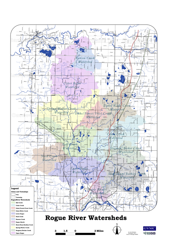
The Rogue River is a major tributary of the Grand River in Michigan's Lower Peninsula. The Rogue River Watershed drains a total of 139,522 acres spanning across Kent, Newaygo, Ottawa, Muskegon, and Montcalm counties. *Find out where you fit into the watershed using the map image below! 
Picture

You can view additional maps of the Rogue River watershed here.

Home

DEQ

Privacy Policy

Contact

Follow us on Social Media! 
Copyright © 2018
  • Home
  • About Us
    • Our Team
    • Our Goals
    • Projects
    • Documentation
  • Resources
    • Riparian Buffer Information
    • Live Water Sensor Data
    • Live Flow Rate
    • MWAT Study 21'
  • Get Involved
    • Donate
    • Subscribe
    • Upcoming Events